
 WWWH on the Forest Service Map
Ok, let's recap all the clues. If I take the first letter from the answers of all 9 clues, here is what I get:
LBJDLPWCC / CCWPLDJBL
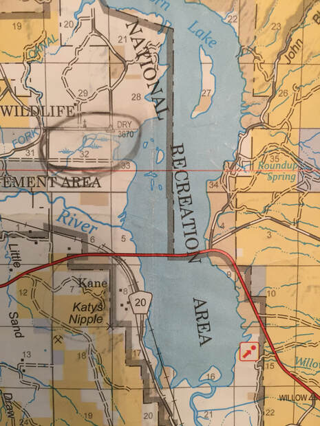
(I later thought that all clues should exist on one map, and working backwards considered WWWH to be box 32 on my Forest Service map, where the Kane-Iona Cemetery is, and the word "dry" is written on the map.
KBJDLPWCC / CCWPLDJBK
Now, I do believe this is some sort of riddle. I have pages and pages of notes trying to figure it out, but I don't know the answer. If I did, maybe I'd have the chest, lol.
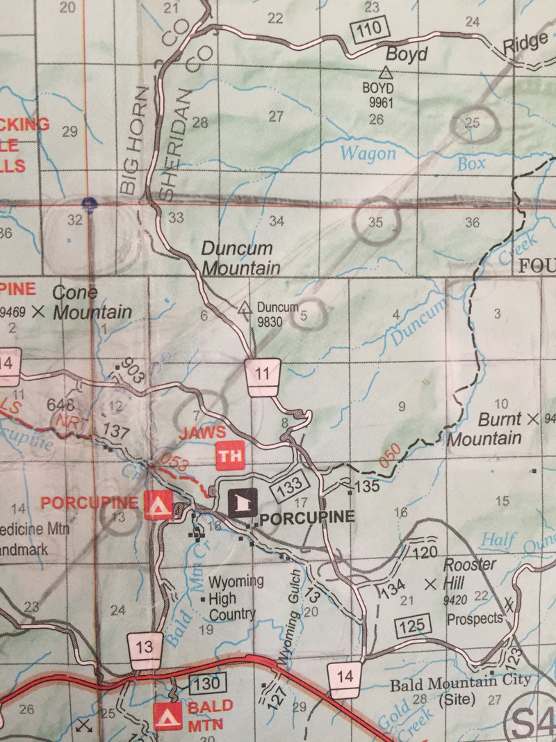
I should mention there is a farm house with a duck pond and also two cabins out there, which Forrest may have stayed at when he was younger. My line goes through both the Cow Camp (black dot 903 on map) farm house and the two cabins on trail #53 (the two black dots at 137).
What line? Well everyone knows that X marks the spot on a treasure map, and I needed to turn my letters above into numbers to do that. Looking through the Scrapbooks posted on Dal's blog, number 107 (also the longitude of my location) had a picture of a phone, and that's when it hit me.
All phones have a key pad that has letters on each number square, and everyone has access to this decoding device.
Here's the link to Scrapbook 107: https://dalneitzel.com/2014/11/12/scrapbook-one-hundred-seven/
LBJDLPWCC / CCWPLDJBL
(I later thought that all clues should exist on one map, and working backwards considered WWWH to be box 32 on my Forest Service map, where the Kane-Iona Cemetery is, and the word "dry" is written on the map.
KBJDLPWCC / CCWPLDJBK
Now, I do believe this is some sort of riddle. I have pages and pages of notes trying to figure it out, but I don't know the answer. If I did, maybe I'd have the chest, lol.
I should mention there is a farm house with a duck pond and also two cabins out there, which Forrest may have stayed at when he was younger. My line goes through both the Cow Camp (black dot 903 on map) farm house and the two cabins on trail #53 (the two black dots at 137).
What line? Well everyone knows that X marks the spot on a treasure map, and I needed to turn my letters above into numbers to do that. Looking through the Scrapbooks posted on Dal's blog, number 107 (also the longitude of my location) had a picture of a phone, and that's when it hit me.
All phones have a key pad that has letters on each number square, and everyone has access to this decoding device.
Here's the link to Scrapbook 107: https://dalneitzel.com/2014/11/12/scrapbook-one-hundred-seven/

So let's see what our acrostics get us:
Clue #1 L or K = 5
Clue #2 B = 2
Clue #3 J = 5
Clue #4 D = 3
Clue #5 L = 5
Clue #6 P = 7
Clue #7 W = 9
Clue #8 C = 2
Clue #9 C = 2
CCWPLDJBK, I read this as 2, 29, 7+5=12, 35, 25. This produced a line on my map that went through Porcupine Creek ("your creek") and created an X. It also creates an X with road 14 (see first image below).
This was my BOTG #2 solve because as you can see on the picture below, it starts at Rainbow Canyon ("will lead to the end of my rainbow") and ends at Wagon Box Creek ("Some say they are trying to think outside the box...until now I have resisted telling them to get back in the box...").
I searched by the NRT on the map, where it makes an X, thinking that Get Gas on Scrapbook 107 referred to a Noble Gas, Radon (RN). T could have been hinted at by Tea with Olga (it's the only T on that section of the map). I really felt strongly that this was the area, but we didn't find anything:(
Now, I know my solve presents some questions, like why would you have to add some numbers (7+5), but not others. I don't have an answer. I'm not claiming that I have the perfect solve. I'm just putting what I have out there, now that "the search is over," in hopes someone reads it and can help me figure out the ending. We haven't received anything from Finder, and Forrest isn't giving up the location, so this is all I can do now. Give it to all of you and see what you make of it.
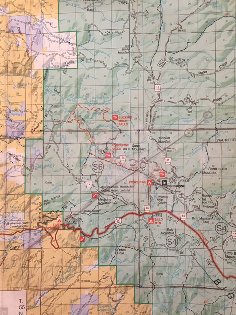
If I would have been able to go back, the latest revision of my solve was to try 2+2+9=13, 7, 5, 35, 25, which puts us right at Jaws Trailhead or by Road 14 (see second image below). I constantly dealt with the dilemma of the chest not being in close proximity to a human trail, and Porcupine Creek being on trail #53, which made me want to focus on Road 14, as well.
I like to think that box 12, trail #53 has a 27 out there to go with it, since Peggy and Forrest's wedding date is 12-27-53.
Here are the pictures, so you can see how these numbers are associated with boxes on the Forest Service map.
Clue #1 L or K = 5
Clue #2 B = 2
Clue #3 J = 5
Clue #4 D = 3
Clue #5 L = 5
Clue #6 P = 7
Clue #7 W = 9
Clue #8 C = 2
Clue #9 C = 2
CCWPLDJBK, I read this as 2, 29, 7+5=12, 35, 25. This produced a line on my map that went through Porcupine Creek ("your creek") and created an X. It also creates an X with road 14 (see first image below).
This was my BOTG #2 solve because as you can see on the picture below, it starts at Rainbow Canyon ("will lead to the end of my rainbow") and ends at Wagon Box Creek ("Some say they are trying to think outside the box...until now I have resisted telling them to get back in the box...").
I searched by the NRT on the map, where it makes an X, thinking that Get Gas on Scrapbook 107 referred to a Noble Gas, Radon (RN). T could have been hinted at by Tea with Olga (it's the only T on that section of the map). I really felt strongly that this was the area, but we didn't find anything:(
Now, I know my solve presents some questions, like why would you have to add some numbers (7+5), but not others. I don't have an answer. I'm not claiming that I have the perfect solve. I'm just putting what I have out there, now that "the search is over," in hopes someone reads it and can help me figure out the ending. We haven't received anything from Finder, and Forrest isn't giving up the location, so this is all I can do now. Give it to all of you and see what you make of it.
If I would have been able to go back, the latest revision of my solve was to try 2+2+9=13, 7, 5, 35, 25, which puts us right at Jaws Trailhead or by Road 14 (see second image below). I constantly dealt with the dilemma of the chest not being in close proximity to a human trail, and Porcupine Creek being on trail #53, which made me want to focus on Road 14, as well.
I like to think that box 12, trail #53 has a 27 out there to go with it, since Peggy and Forrest's wedding date is 12-27-53.
Here are the pictures, so you can see how these numbers are associated with boxes on the Forest Service map.
BOTG #2 Solve
Would have been BOTG #3 Solve
